Wednesday, February 29, 2012

weather 2/29/12

Unfortunately, classes were not cancelled today due to the weather, however high schools throughout the area and into MN were cancelled due to icey roadways and snow. As of last night the pressure system was still to our south and was pumping up moisture with winds from the east/southeast. Around 10pm last we had already received around 5.5 inches of snow, but the precipiation then changed over to a freezing rain. There were a few acciendet along state street last night as well due to the icy conditions. There is more rain and ice to our south and evn further south there are tornado watches and warnings takking place. More than 15 tornadoes have already occured on the southern edge of this system and more are expected in the southeast today. In Branson, MO there have been already 13 deaths associated with the tornado outbreak and more tornadoes are moving into southern Kentucky.  Currently, the snow total is now up to 7.7 inches and the low pressure system is sitting right over the twin cities area and is spinning counterclockwise. However the system is now dying due to the occluded front associated with it. See map below.  Snow expectations  are around 2-3 inches for today and the winds are now from the south at 20mph. Addionally, the barometer has been steadily dropping since last checked around classtime yesterday.


US: Current Weather


Precip totals so far

Tuesday, February 28, 2012

weather 2/28/12

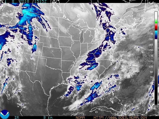
This storm that formed out in the Rockies also known as a Colorado low, will be the most significant storm for this entire winter. However, it appears that the worst of the storm will pass north of Eau Claire which is unfortunate for all of those, including myself who were hoping for classes to be cancelled tomorrow. The Eau Claire area is only expected to receive around 1-3 inches of snow, along with sleet, ice, and rain mixed in at times as well. There is also a small chance for there to be ice accumulating throughout the rest of Tuesday and into Wednesday morning. Regardless travel will be very hazardous and especially with the ice/sleet is not advised. As the low pressure system moves into the upper midwest moisture from the gulf will pump up into the region providiign the areas north where the system is moving with abundant snowfall, up to a foot in places or more. Areas to the south in the moist warmer air will recieve less snow, or just recieve rain/ice. Currently, the temperature is just above freezing and the winds are from the SE at 10mph. This is good news that there will be at least some snow in the afternoon. The graphics below illustrate the storm and its predicted track.


Major Winter Storm

current color enhanced goes east infrared image

Monday, February 27, 2012

weather 2/27/12

An area of low pressure over the Southern Rockies is expected to head northeast and hit the Central Plains.  This system will be rich in both moisture from the low pressure system and gulf moisture hitting the cold air mass. Thus allowing for there to be very large snowfall amounts expected throughout MN and WI.  In the Eau Claire area about 4-8 inches of snow are expected throughout Tuesday and Wednesday, with rain/snow mixed in as well. As you head south and south west however, the storm will be less intense and will be mostly rain/snow mixed. There are a few possible tracks that this storm could have it could go farther north bringing Duluth more snow instead and Eau Claire only getting grazed by the storm or we could have up to 12 inches of snow if the storm decides to stay south.

Sunday, February 26, 2012

weather 2/26/12

An occluded front and a low pressure system are sitting to the west of the eau claire region today bringing with it cloudy skies, warm temperatures, and a chance for precipitation into tonight and tomorrow. Winds are howling from the SW at 25 mph and the as the front moves through temperatures should be dropping by almost 20 degrees tonight. Most of the moisture is fore casted to stay to the south and there is only a 30% chance of snow tonight.

Saturday, February 25, 2012

weather 2/25/12

The Eau Claire regions weather for today is clear skies with a high of 25 degrees today with high pressure dominating the region throughout the day. Into tonight a small front will be moving into the region bringing with it warm temperatures again and a slight chance of snow tonight and into tomorrow morning early. Another interesting weather event in the country is the area of low pressure  that is intensifying over New England and eastern Canada. Strong winds from the west will be blowing across the lower Great Lakes and eastern coast. See map below

Friday, February 24, 2012

Finally some colder air has moved into the eau claire area. The high today was 26 degrees and around 1pm there was snow flurries. No accumulations of snow, but the sight was welcoming. Tonight there is a 30% chance of snow flurries into the overnight hours and winds will be from the WNW at 25 mph. These winds will be funneling the colder air down into the area and the low for tonight will be around 14 degrees. The rest of the weekend looks like it will be around average for temperatures.

Thursday, February 23, 2012

weather 2/23/12

Today is more of the same old warm temperatures with highs reaching around 40 degrees yet again today. currently the skies are cloudy with low stratus clouds moving in from the west. There is a slight chance of snow tonight due to the fact that there is a low pressure system sitting to our north and our south, however the chance of snow is only 30% through tonight and into tomorrow. Tomorrow's forecast looks like a few snow showers and winds will be from the WNW.

Satelite Image

Wednesday, February 22, 2012

weather 2/22/12

Todays weather is more of the same, warm temperatures (around 37 degrees), sunny skies and light winds. The winds will be from the WSW at 10mph and the chance of precipitation is around 30-40% through tonight. There wil be no snow accumualting however due to the slight chance. Tonight the low will be 25 degrees and the skies will be clear throughout the night. Into tomorrow the winds will shift to the SSE and there will be another system moving into the EC area brining with it another chance of snow. This winter still has proven to be the wamrest winter on record for the Eau Claire region. See map below.  However within the next few days cold air will be moving back intot he region bringing with it a chance of snow!


demo

Monday, February 20, 2012

weather 2/20/12

Todays weather is expected to be cloudy conditions, around 39 degrees, with winds from the SSE at 20-30mph. A low pressure system to the south west will be moving into the area around nightfall with a 70% chance of snow. The amount of snow will vary due to the winds blowing in. The winds will then switch to the SW at 25 mph. The expected amount of snow for the Eau Claire area will be around 2 inches. Tomorrow's high will be 36 degrees with snow flurries tapering off around midday. The warm temperatures will proably melt the snow that we will get which is unfortunate.

Satelite Image

Sunday, February 19, 2012

weather 2/19/12

Another cloudless day for the Eau Claire area with highs in the upper 30's to low 40's with a 10% chance of precipitation tonight. The low for tonight will be around 20 due to the clear skies. A occulated front and low pressure system will be moving in later tomorrow bringing with it clouds and a chance of rain and snow mixed (50%) chance. The snowfall total will be around 2 inches estimated. This is good news for the severe drought that we have experienced this winter and hopefully this storm will yield more than the estimated amount.

US: Current Weather

Saturday, February 18, 2012

weather 2/18/12

Today the weather for the region will be a bit colder than yesterday at 32 degrees with winds from the W at 5-10mph. The skies will be perfectly sunny with no chance of precipiation in the near future. Tonight the temperatures will drop due to the lack of cloud cover and winds will switch to the SSE at 10mph with a high pressure system dominating. To the east there is a strong cold front moving in to the atlantic states providing them with lots of heavy snow north of North Carolina and to the south with severe weather and 3-4 inches of rain expected in some places. This is great news for the southeast becuase they are in a drought just like the upper midwest is, however we really need that moisture as well.

Thursday, February 16, 2012

weather 2/16/12

Evaporation fog will give away to sunny skies with highs in the upper 30's to low 40's today. The low pressure system that moved through the state yesterday has now left and is providing Michigan with precipitation and lots of foggy conditions. There is a high pressure system to the west of the area and will move in during the later part of the day. The barometer is on the rise at 30.56 and the chance for precipitation is 10%. Despite these abnormally warm temperatures, there is a abnormal cold snap still occurring out in north Africa and in southern Europe. Snow has fallen in Algeria and other parts of the Mediterranean. I sure wish we could get some of that snow!

US: Current Weather

Wednesday, February 15, 2012

weather 2/15/12

Another day of above average temperatures will blanket the region today. The high for the eau claire area will be around 40 degrees with haze in the early morning hours due to evaporation fog. The barometer is falling to 29 millibars. Winds will be from the NW at 5 mph and there is a slight (30%) chance of rain this afternoon into the early evening. With the evaporation of the fresh snow, there will be fog into the overnight hours and visibility will diminish to around 5 miles. This weather pattern seems to be the trend for the 2012 winter. It is unfortunate that we will loose the fresh snow that we just got a few days ago.

Tuesday, February 14, 2012

weather 2/14/12

The snowfall total from yesterday's event was 1.1 inches. Today's forecast and into tonight calls for cloudy skies with temperature hovering around 30 degrees and dropping to a low of 25 degrees. The chance of snow into tonight is still around 50% and snowfall totals for tonight are expected to reach .5 inches. Winds from the SSE at 10mph will be pumping up the moisture to fuel the snowfall event. Tomorrow, temperatures will rise into the upper 30's and a low pessure system and stationary front makes its way into the upper midwest. This system will provide the eau claire area with warm temperatures for the rest of the week and melt the fresh snow on the ground unfortunately.

Satelite Image

Monday, February 13, 2012

weather 2/13/12

Today's forecast calls for cloudy conditions with a 70% chance of snow throughout the afternoon and into the earlier evening. The amount of snow is expected to be around a quarter to a half of an inch. The high for today will be a steady 26 degrees. Winds will be from the SSE at 10 mph which is providing the moisture to help fuel the snowfall that is expected. The barometer is also dropping which shows that a weather system is moving in quickly. The colder air provided by a high pressure system will be sitting up in northern MN today and will funnel cooler air to provide snow instead of rain.

current color enhanced goes east infrared image

Sunday, February 12, 2012

weather 2/12/12

Today is forecasted to be much warmer than yesterday's frigid temperatures. The high for today will be around 26 degrees with winds from the SW at 10 mph. The skies will be clear all day with abundant sunshine with a high pressure system dominating. However, a stationary front which is over the Rockies is forecasted to bring with it snow to the region by tomorrow afternoon. The precipitation chance for tomorrow is 50% chance of snow with a high of 31. Hopefully this front will bring with it precipitation. forecasters are already predicting a very dry spring and a high chance of a drought for the upper Midwest.

Saturday, February 11, 2012

Weather for 2/10/12 and morning of 2/11/12

Today is one of the coldest days of the 2012 year so far. The wind chill feels like it is -15 degrees and the winds are howling out of the NW at 20 mph. The sun is out and the sky is clear, which makes it look deceptively warm outside. Earlier this morning, was coldest part of the day, around 5:45AM, the low was -4 degrees. The colder temperatures are welcoming and are normal for this time of year, however I wish this Arctic air mass from Canada brought snow with it. The forecast shows no snow in the near future, just more cold arctic air funneling down from the NW.

Thursday, February 9, 2012

weather 2/9/12

Today the winds from the SW will bring warmer air and abundant sunshine from the south giving the Eau Claire area a high of 35 degrees. However as the day progresses and the sun goes down, the sky will be clear tonight and the temperature will drop due to the dry air and the clear skies. The low for tonight will be 10 degrees. Additionally the winds will increase and switch to the NW at 30mph which will make the wind chill almost 0 degrees tonight. There is a slight chance of precipitation tonight (snow flurries) however, it is unlikely.

Wednesday, February 8, 2012

weather 2/8/12

Today's weather is much colder than yesterday with highs only in the mid 20's with abudant sunshine all day long. As the day progresses temeratures will be falling into the upper teens and winds will be from the WNW at 10mph. As the night progresses the winds will switch and bring warmer air from the south and tomorrows high will be around 35. This winter certainly has been one of the warmest winters on record ever and it appears to stay on this warm trend at least another week or so.


Tuesday, February 7, 2012

weather 2/7/12

Today's forecast is expected to be partly to mostly sunny with highs in the upper 20's to near 30 degrees throughout the afternoon. Winds will be from the north at 5-10mph and temperatures should stay steady. Tonight the remaining clouds will clear and the temperatures will plummet to 10 degrees tonight which is the coldest it has been in over two weeks! Winds will also switch to the NW and barometer will be on the rise as colder air moves into the region. Despite the cold air moving in the chance of precipitation will be 0% throughout the rest of the day and into tonight.

Satelite Image

Monday, February 6, 2012

weather 2/6/12

Today's weather calls for mostly sunny skies with temperatures rising to near 38 degrees.  The winds will be from the W at 5 to 10 mph. Chance of precipitation will be 20% throughout the day and will be increasing as the day progresses. As a cold front dips from northern Canada tonight the winds will shift to the NNE at 15 mph and there will be a chance of flurries throughout the overnight hours. The low for tonight will be a chilly 19 degrees after the front moves through. Tomorrows high will be much lower after the front passes through peaking at 23 degrees. Hopefully this cold front will bring some much needed precipitation in this already dry winter!

US: Current Weather

Sunday, February 5, 2012

Weather 2/5/12

Today's weather is forecasted to be mostly sunny in the early morning hours with a low stratus cloud deck rolling in around noon with highs in the upper 30's. Temperatures will steadily decline to the low 30's as the clouds move in during the afternoon hours. Tonight's forecast is cloudy with winds coming from the WSW at 10mph. The low for tonight is 24 degrees with patches of evaporation fog forming around midnight tonight. The chance of precipitation for today and tonight is 10% and the barometer is on the rise at 30.3.

US: Current Weather

Saturday, February 4, 2012

Weather 2/4/12

The weather for today calls for low clouds, freezing fog improving into the afternoon around 1 pm. The clouds will decrease by 5pm  and temperatures will be rising up to 38 degrees. Winds will be from the NW at 5 to 10 mph. Tonight the winds will switch the NNE at 10mph and party cloudy conditions will follow with temperature dropping into the low 20's. There is a large upper level low to the south creating lots of snow and rain down south and pumping warmer air up into the upper midwest. Evaporation fog has been in the region for the last couple days due to this low pressure system pumping up warm air and melting the snowpack.

US: Current Weather

Friday, February 3, 2012

Weather 2/3/12

Todays weather forecast calls for yet again more fog and cloudy conditions with a high temperature of 37. As the day progresses the sun will burn through the low stratus cloud deck and hopefully burn off the dense cover.Winds will be from the NE at 10 mph and will decrease as the afternoon progresses. Tonight's forecast calls for party cloudy conditions with a low of 22 degrees with light winds from the NE. The chance of precipitation is 20% and will remain 20% throughout the day and into tonight. The forecast ahead shows no signs of significant precipitation with a high ressure system to the north dominating. Additionally, the jet stream is helping funnel the cold and moist air int the middle of the country thug giving Denver a massive snowstorm yielding in 2 feet of snow already today. I wish we had that snowstorm!

US: Current Weather

Thursday, February 2, 2012

Weather 2/2/12

Today the weather is supposed to be early evaporation fog burning off during the afternoon with party cloudy skies showing up later in the day. Around nightfall the clouds roll back in and it will stay cloudy the rest of the night.  The high temperature for the day will be 37 and a low of 24 degrees. Winds from the northwest at 2 mph, the humidity is at 85% , and the barometer is on the rise (30.3in) which shows signs of improving weather conditions into tomorrow.

US: Current Weather
www.weather.com/maproom

Wednesday, February 1, 2012

Weather 2/1/12

Today's forecast calls for low stratus cloud cover, around 100% cover. Fog and low visibility will start to diminish in the next hour or so, and the thick cloud cover will star to diminish as the day progresses. The temperature will be at a steady 34-35 degrees all day and the winds will be coming from the South at 10mph. Tonight's forecast calls for a 30% chance of snow flurries with cloud cover and sunshine mixed. The low for tonight will be 25 degrees. Thicker fog will be developing to the south and west of Eau Claire today with alerts already issued, but I believe that Eau Claire shouldn't have as dense of fog as southwest WI and eastern Minnesota. Additionally, a high pressure system just tot the south will be dominating the rest of today and into tomorrow morning.

US: Current Weather
current surface

US: Severe Weather Alerts
current alerts

Both maps taken from www.weather.com/maproom